

The problem: systems talk, but safety doesn’t listen
Vehicles talk. Systems talk. But they speak different languages. GPS units report. Route software plans. Reports pile up. Yet collisions still happen. This is the problem. Solutions borrowed from school bus fleet management, like tight GPS tracking, clear route management, and concise fleet reporting, help when adapted for heavy sites — see mining fleet management. The mismatch is process. And people need simple signals, not noise.
Why it fails — blunt causes
Short list. Concrete causes:- Fragmented data: location, speed, and proximity in separate silos.- Delayed alerts: warnings arrive after the fact.- Complex displays: operators ignore long dashboards.- No closed loop: events recorded, but no corrective action assigned.Each cause multiplies risk. Each makes collision avoidance reactive, not active.
What truly matters in integration
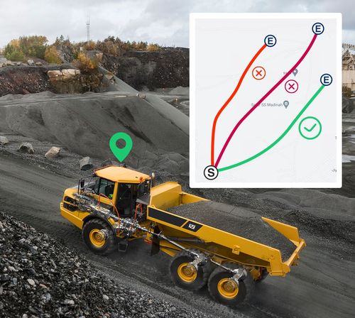
Focus on these core pieces. Keep them small. Make them interoperable.- Accurate GPS tracking: consistent position, frequent updates, timezone-proof timestamps.- Route management: simple geofences, clear staging routes, and predictable ingress/egress paths.- Fleet reporting: concise, actionable summaries — not spreadsheets.- Real-time proximity layer: a dedicated collision layer that fuses sensors and telematics. This is where a robust mining collision avoidance system lives.I’ve overseen surface-mining integrations for over a decade; success comes when these parts speak one protocol and one purpose.
Practical steps — the starter checklist
Start small. Move fast. Repeat.- Baseline: map routes and blind spots. Use simple drives, in daylight and dusk.- Sync clocks: universal timestamps across devices.- Prioritize alerts: near-miss, stop, reroute — three levels only.- Test scenarios: blocked haul roads, equipment breakdowns, vehicle overtakes.- Train crews: short drills, repeated. Keep them under ten minutes.Avoid long rollouts with features nobody asked for.
Pitfalls and what to avoid
Direct warnings.- Don’t overload operators with non-actionable alerts.- Don’t rely on one sensor type. Radar-only or camera-only will fail in dust.- Don’t postpone audits; monthly checks find drift early.- Don’t assume OEM defaults match site reality.One truth: complexity breeds gaps. Simplify until the team trusts the system.
Options and trade-offs
Compare plainly.- Full-stack vendor: faster rollout, higher initial cost, vendor lock.- Best-of-breed mix: flexible, needs strong integration discipline.- Open protocols: future-proof, needs in-house capability.Choose by capability, not by buzz. For many operators, phased best-of-breed yields balance: start with vendor-tested collision layers, then add specialized reporting and route tools.
Anchor from the field
Pilbara region of Western Australia taught operators a blunt lesson: scale amplifies every gap. Large haul networks there tested automated proximity alerts and reinforced that real-time fusion and human workflows must match. Trials in big iron-ore operations showed that simple routing discipline plus fused proximity systems reduced operational confusion.
Short synthesis
Fix the vocabulary first. Make GPS, route logic, reports, and proximity speak one language. Test with clear scenarios. Train simply. Watch for sensor gaps and audit often. That practical, stubborn clarity is what operators need — and what teams like BSJ build into solutions that keep heavy sites predictable and safer.

